
Some real incidents teach us how to use technology in the right way. The horrific incident that happened on June 24, 2026 took away the lives of 235 people, with more than 1,500 injured in the Venezuela Earthquakes. Meanwhile the earthquake on June 27 reached the death toll to nearly 920 people with more than 3360 being injured.
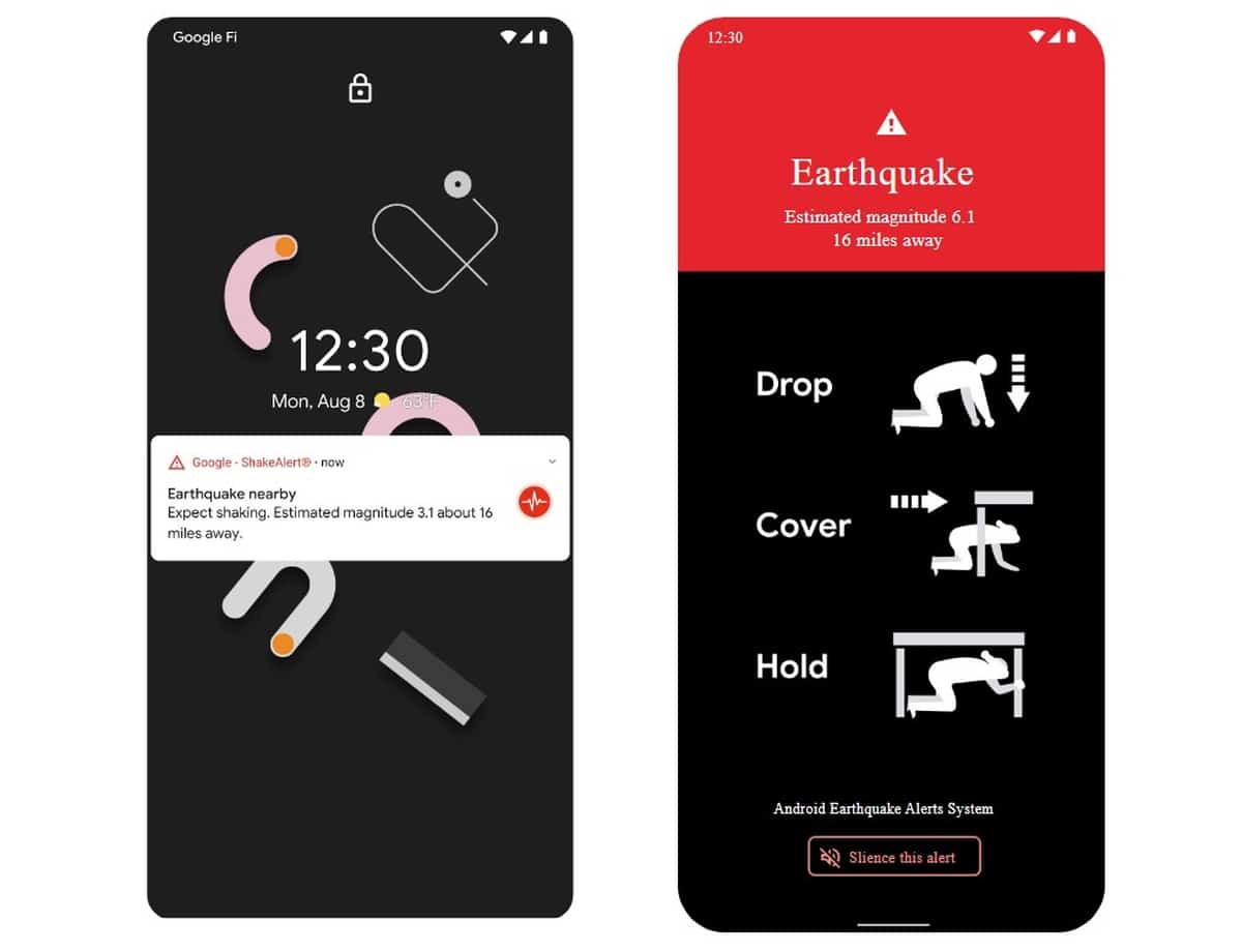
Despite the situation being so devastating, there is another thing to notice: Google's Earthquake Alerts System alerted people in real time before the intense shaking was felt. Millions of people in Venezuela received a warning on their Android phones moments before the ground began to shake.
The real question raised here is whether to believe the information is true or not — and how does Google supposedly know before the ground began to shake?
The answer is clear: Google did not predict the earthquake. Instead, its Android Earthquake Alerts System detected the very first signs of seismic activity and pushed warnings to nearby users before the more destructive shaking reached them.
Nikhar Arora, Director at BOTS.Ai by HR Anexi, explained it well: "It was not Google who predicted the occurrence of the earthquake, but rather detected the very beginning signs and sent out an alert well before the intense shaking began."
The system works by leveraging the physics of earthquakes. Every quake produces two types of waves — fast-moving P-waves (Primary waves), which are relatively weak, and slower but far more destructive S-waves (Secondary waves). Android phones detect the P-waves first using built-in accelerometers. That data is instantly sent to Google's servers, which confirm the quake using signals from multiple devices and push alerts to users in affected areas.
"Earthquakes are a constant threat to communities around the globe. While we've gotten good at knowing where they're likely to strike, we still face devastating consequences when they do. What if we could give people a few precious seconds of warning before the shaking starts? Those seconds can be enough time to get off a ladder, move away from dangerous objects and take cover," Google Research Team, cited in its Science journal alongside the Android Earthquake Alert system performance report (2025).
.jpg) Launched in April 2021 starting with New Zealand and Greece, Google's Android Earthquake Alert System has since expanded to 98 countries. The core idea was simple but powerful: billions of Android phones already carry accelerometers — why not turn them into the world's largest distributed seismic network? Since launch, the system has detected over 18,000 earthquakes and sent 790 million alerts, expanding early warning access from 250 million people to 2.5 billion worldwide.
Launched in April 2021 starting with New Zealand and Greece, Google's Android Earthquake Alert System has since expanded to 98 countries. The core idea was simple but powerful: billions of Android phones already carry accelerometers — why not turn them into the world's largest distributed seismic network? Since launch, the system has detected over 18,000 earthquakes and sent 790 million alerts, expanding early warning access from 250 million people to 2.5 billion worldwide.
It is important to understand what the system does and does not do. Earthquake prediction — knowing when and where a quake will strike before it happens — remains scientifically impossible. What Google built is an early warning system: it detects the moment a quake begins and races that information to nearby users before the most damaging waves arrive.
Hrishit Panthry, Co-founder of Envirocare Foundation, following the June 2026 Venezuela earthquakes said, "Although it is impossible to predict earthquakes, it is possible to use technology to detect them immediately and communicate the news as quickly as possible to prevent injuries and deaths."
Earthquakes strike without warning and without pattern. Unlike floods or hurricanes, there is no forecast, no countdown. Even a 5 to 60 second window has measurable, life-saving consequences — trains can halt automatically, surgeons can pause procedures, schoolchildren can take cover, and nuclear plants can trigger shutdowns before the worst shaking arrives.
The Himalayan region makes this urgency especially vivid. Sitting at the collision of the Indian and Eurasian tectonic plates, cities like Delhi, Kathmandu, and Dehradun are densely populated, high-risk zones with limited national early warning infrastructure. The 2015 Nepal earthquake killed nearly 9,000 people. For the Himalayan belt — one of the most seismically active regions on Earth — a smartphone-based warning system is not a luxury. It is a necessity.
Also Read: Importance of Integrating Robust Fire Safety Systems
|
Year |
Earthquake |
Magnitude |
Deaths |
Country |
|
1556 |
Shaanxi earthquake |
~8.0 |
~830,000 |
China |
|
1906 |
1906 San Francisco earthquake |
7.9 |
~3,000 |
United States |
|
1920 |
Haiyuan earthquake |
8.3 |
~273,000 |
China |
|
1960 |
1960 Valdivia earthquake |
9.5 |
~1,600 |
Chile |
|
1964 |
1964 Alaska earthquake |
9.2 |
~131 |
United States |
|
1976 |
1976 Tangshan earthquake |
7.5 |
~242,000 |
China |
|
2001 |
2001 Gujarat earthquake |
7.7 |
~20,000 |
India |
|
2004 |
2004 Indian Ocean earthquake and tsunami |
9.1 |
~230,000 |
Multiple countries |
|
2005 |
2005 Kashmir earthquake |
7.6 |
~87,000 |
Pakistan |
|
2008 |
2008 Sichuan earthquake |
7.9 |
~87,000 |
China |
|
2010 |
2010 Haiti earthquake |
7.0 |
~220,000 |
Haiti |
|
2011 |
2011 Tōhoku earthquake and tsunami |
9.1 |
~20,000 |
Japan |
|
2015 |
2015 Nepal earthquake |
7.8 |
~9,000 |
Nepal |
|
2023 |
2023 Turkey–Syria earthquakes |
7.8 |
>59,000 |
Türkiye & Syria |
|
2024 |
2024 Noto earthquake |
7.5 |
~732 |
Japan |
The amount of warning time depends on how far you are from the epicentre. Here is what those seconds can realistically mean:
Experts recommend using every second for the universal safety action. Even three seconds used wisely can ultimately reduce the risk of injury from falling debris, broken glass, or structural collapse. In emergency situations, those seconds can make a critical difference — people can move away from dangerous structures, pause hazardous activities, or seek safer locations.
 What makes Google's approach genuinely remarkable is not just the speed — it is the scale and accessibility of the system. Here is why smartphone-based earthquake detection is changing disaster preparedness:
As powerful as this technology is, it is important to be honest about what it cannot yet do:
“As we step forward on this path, it is evidently clear that if we utilize technology in the proper way, it will benefit us in ways we are only beginning to understand,” Thiruamuthan T K, Correspondent, The Industry Outlook.
.jpg)
Artificial Intelligence is revolutionizing earthquake detection by shifting from traditional reactive methods to faster, more accurate, and proactive systems. Deep Learning models, such as the Earthquake Transformer developed by Stanford researchers, analyze seismic waveforms with over 90 percent accuracy in phase picking, detecting thousands of previously missed small earthquakes in noisy urban datasets. These models process data up to 100 times faster than conventional methods, enabling real-time alerts.
Edge AI deploys ultra-lightweight convolutional neural networks on low-power devices like smartphones and Raspberry Shake sensors. Recent studies show these models achieve real-time P-wave detection with minimal latency on edge hardware, expanding coverage in areas with sparse official stations.
"AI cannot prevent natural hazards like earthquakes. It can, however, support faster, smarter, and more targeted interventions that help lessen the impact for people when a disaster occurs." — Dr. Monique Kuglitsch, Fraunhofer HHI
Satellite integration and GPS deformation monitoring track ground shifts with millimeter precision over hundreds of kilometers. IoT sensors in dense arrays provide granular data, while fiber optic sensing converts existing telecom cables into distributed acoustic sensors capable of monitoring hundreds of kilometers of fault lines. Smart city networks and real-time data fusion algorithms integrate these streams—seismic, GPS, satellite, and IoT—reducing false alarms by up to 50 percent in pilot programs and improving magnitude estimates within seconds.
Also Read: The Shift Toward Modern Infrastructure and Smart Design
Emerging technologies could extend warning windows significantly. AI-based seismic forecasting uses machine learning on historical patterns to identify precursors, with some models showing promise in forecasting aftershock sequences with 70-80 percent reliability. Quantum sensors detect subtle gravitational fluctuations; controlled studies indicate potential warnings up to hours ahead by sensing pre-seismic stress changes.
Satellite radar (InSAR) monitors deformation at scale, successfully mapping pre- and post-event shifts in major quakes. Smartwatches and connected vehicles could add millions of additional data points daily. IoT smart homes enable automated responses, while drone-assisted disaster assessment provides imagery within minutes. Digital Twins simulate city-wide impacts in real time, and Edge Computing with 6G communication targets sub-millisecond latency. Space-based monitoring offers global offshore coverage, critical as over 70 percent of major earthquakes occur underwater.
Governments must lead with data-driven policies. Implementing open seismic data platforms has accelerated research, as seen in California’s ShakeAlert system, which partners with Google to alert millions via Android devices. Comprehensive national sensor networks, like Japan’s thousands of stations, provide seconds-to-minutes warnings. Telecom integration and emergency broadcasting ensure 90 percent population reach, as demonstrated in successful deployments.
“By fusing crowdsourced mobile data with advanced AI and quantum sensing, we can transform seconds of warning into minutes of preparedness, saving lives at unprecedented scale,” said Dr. Elena Vargas, Seismic AI Director at Global Disaster Tech Institute.
Public education campaigns, combined with regular drills, increase survival rates by 30-50 percent in tested regions. Strict building code enforcement in zones like Chile has dramatically reduced casualties in recent decades. Cross-border alerts are essential; integrated systems in the Pacific could protect hundreds of millions. By blending official infrastructure with crowdsourced data—Google’s system alone issued timely alerts during the 2026 Venezuela quakes, saving lives through 3-10 second warnings—governments can create multi-layered systems.
Integrating these advancements with robust policy can reduce earthquake impacts worldwide, turning data into actionable safety. "The technology to save the next 100,000 lives from earthquakes already exists. What is missing is not the sensor, the satellite, or the algorithm — it is the political will to deploy them before the next fault line decides to move." — Ajay Sunny, Correspondent, Industry Outlook.
When you receive an earthquake alert, the critical action should be Drop, Cover and Hold on. This is to protect oneself from the falling debris or flying glass. With respect to the alert consider these two possibilities of:
In case of no such hideout nearby, crouch next to a wall away from windows, heavy furniture and other appliances. Lastly hold on, grip your shelter firm with one hand and protect your head and neck with the other hand, until the shaking stops.
Make sure to keep emergency kits especially for earthquake prone areas. While the alert has come, try not to use elevators, in case of driving, pull over somewhere empty and open space and try to stay in the car. Always wait for the official updates to avoid rushing on to conclusions based on rumors.
The earthquakes in Venezuela have demonstrated how smartphones are becoming a crucial component of the Early Warning System (EWS). The Android phones are equipped with accelerometers that can detect the unusual ground motion.
Within seconds the alert can be sent to the users in surrounding areas, giving them time, as the alert may provide a few seconds or a minute in some cases, to seek safety before the shaking. By combining built in sensors with cloud based data analysis, Google's Android Earthquake Alert System, provides millions of people with valuable time to react before the disaster.
As the technology is further expected in expansion, smartphone based earthquake detection aims to strengthen the global disaster preparedness and help in reducing the impact of future seismic events or other hazardous natural disasters.
“Google’s Android Earthquake Alert System and its heads-up on the recent earthquakes, really demands more enhanced developments on smartphone detecting various other natural disasters, saving lives in seconds or over a minute difference.” — Fathima Noud, Correspondent, The Industry Outlook.
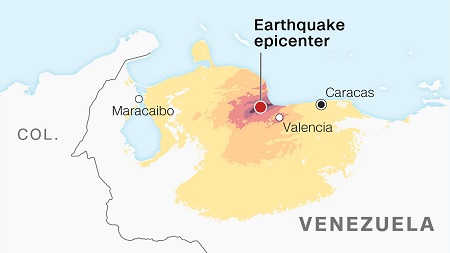 The consecutive seismic events in Venezuela, California, Japan, raise the concern of whether it is related to any greater cause. A 5.6 magnitude earthquake struck rural northern California whereas a 7.2 magnitude earthquake occurred in Japan.
Venezuela was shattered by two powerful earthquakes, of magnitudes 7.2 and followed by the quake of 7.5 magnitudes. Although reports suggest that the earthquake occurred specifically in California, Japan and Venezuela was in the span of eight hours. But experts confirm that they are not connected.
As in the Philippines the southwest of Mindanao Island was hit around 6.8 magnitudes, and Indonesia had a similar violent quake of magnitude 7.4 in the Northern Molucca on April. In addition another quake occurred in Central Sulawesi of Indonesia on June 16 as well of 6.7 magnitudes.
The Venezuela earthquakes of June 2026 were a stark reminder that the Earth does not wait. But they also showed something quietly remarkable — that the phone in your pocket is no longer just a communication device.
It is part of the world's largest early warning network. Google's Android Earthquake Alert System cannot stop the ground from shaking, but it can give you the seconds that matter most. As technology continues to evolve, the real work lies in ensuring these tools reach every corner of the world — because a warning that does not reach everyone is a warning that is not finished yet.
"Technology cannot predict when the Earth will shake, but it can make sure that when it does, no one faces it without a warning. The real measure of innovation is not how fast it moves — it is how many lives it reaches." — Zeenat Parween, Correspondent, The Industry Outlook.


We use cookies to ensure you get the best experience on our website. Read more...
")


